New version : Reports for Geoconcept 2.0
GEOCONCEPT announces Reports for Geoconcept 2.0, the new version of its report design and generation solution
Reports for Geoconcept 2.0 s’enrichit de nouvelles fonctionnalités et offre ainsi aux utilisateurs une solution plus complète et ouverte mais aussi une Reports for Geoconcept 2.0 boasts new features, thereby offering users a more comprehensive and open solution while also being easier to pick up for quickly editing customized and comprehensive reports.
Need mapping options to replace MapPoint solution
Microsoft MapPoint was discontinued on 31/12/2014.
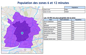
You do not have any software to visualize and analyse your business data anymore?
GEOCONCEPT offers alternative solutions to MapPoint.
Discover the GIS range of products of GEOCONCEPT: simplicity, performance and scalability!
Discover alternative solutions to MapPoint data visualization solution
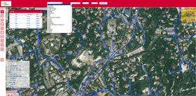
MapPoint was your trusted companion to visualize and analyse your routes optimized with TourSolver?
Since Microsoft MapPoint has been discontinued, are you looking for an alternative?
GEOCONCEPT has the solution: discover Geoconcept TourSolver, the easy-to-use and complete tool for route optimization!

GEOCONCEPT & SYSTEL value their partnership at Interschutz in Hannover
GEOCONCEPT & SYSTEL value their partnership at Interschutz in Hannover.
Both partners will present their solutions dedicated to the fire and rescue services on the French Pavilion at the Interschutz exhibition in Germany, from 8th to 13th of June 2015 (hall 26, booth E 03).
GEOCONCEPT and SYSTEL are now exporting their expertise, among their customers:
- In France, the Marseille’s Navy Firefighters Battalion (BMPM) has been using the STARTOPS system since 2014 in an operational control room with some forty workstations capable of handling one million calls and 114,000 responses per year. The system features a cartographic base administered by the office for the management of urban data, which has been using Geoconcept solutions for some fifteen years. SYSTEL’s alert system provides innovative tools that have made it possible to take advantage of the BMPM’s cartographic base.
- Geoconcept and SYSTEL solutions also help the Fire & Rescue Services of HAUTE-SAVOIE to have an operational control room handling emergency calls 18 and 15 (emergency phone numbers in France). SYSTEL has provided a unified system capable of handling mobilisations involving the 2 organizations. A decision support system designed by SYSTEL with a feed from the Fire & Rescue Services of Haute-Savoie enables support to be provided to the operator by means of a questioning tool. The geolocation of the appliance mobilisation ensures accurate tracking on the cartographic system and commitment of an available appliance to be mobilised faster on an incident.
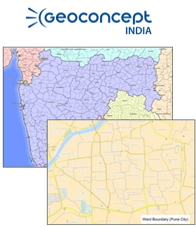
New census data For India
GEOCONCEPT India brings out a complete and detailed grid of the administrative divisions of India as per census 2011 from state to the village/town unit level and additional ward level units for major cities of India. With about 595904 administrative units and over 99 % of the population mapped at village and town level, this dataset is one of the most comprehensive version of the Indian census 2011 administrative divisions available in the market today.
GEOCONCEPT India also offers the Indian census 2011 socio-demographic data as a standard along with the administrative unit mapping which includes 85 statistical demographic indicators and will shortly also include approximately around 125 amenities, households and economic statistical indicators.
As a further value addition, for more effective and accurate geo-marketing analysis, GEOCONCEPT India also provides a complete integration of the census 2001 and census 2011 statistical variables at the unit level. This data set will enable the user to analyze growth trends and temporal changes in various demographic, amenities and assets indicators across regions
Enhancement of Geomarketing offering in China
GEOCONCEPT enhances its Geomarketing offering in China
New version Geoconcept Web 5.1
GEOCONCEPT launches Geoconcept Web 5.1, the new version of the geographical information publishing solution.
Incorporating innovative Responsive Design technologies, Geoconcept Web 5.1 offers users new features and a responsive mode, providing an optimal experience when viewing web portals built with the solution.

Prizes in China : “Best Logistics Operations Optimization Solution”
The China Communications and Transportation Association rewards GEOCONCEPT geo-optimization solutions
The Opti-Time and TourSolver solutions have just won two prizes at a biennial ceremony organized by the China Communications and Transportation Association. These prices reward technologies enabling Chinese companies to be better positioned to improve their performance on the ground.

GEOCONCEPT and HERE leverage their partnership in Latin America
GEOCONCEPT, the designer of geographical optimization technologies for professionals, and HERE, the cartographic and location services provider, are announcing their joint participation in the ANTAD exhibition, the hub for players in the retail supply chain markets, which will take place in Mexico City from 18-20 March.