Formation E-learning
Comprising a number of product and business learning programs, the E-Learning platform enables you to understand the principal features of the Geoconcept product range.
 
Each sequence comprises a theoretical element, its practical application in a scenario and exercises to recapitulate and consolidate what has been learned. The entire program can be revised as expectations and needs dictate; self-learning thus ensures that knowledge will endure.
 
E-Learning training courses involve learning about the Geoconcept kernel, the Sales & Marketing solution, the Geoconcept Universal Geocoder geocoding module, and recently, TourSolver for Geoconcept module.
 
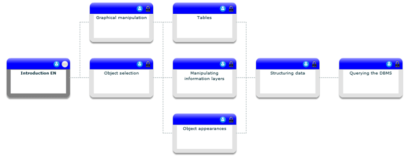
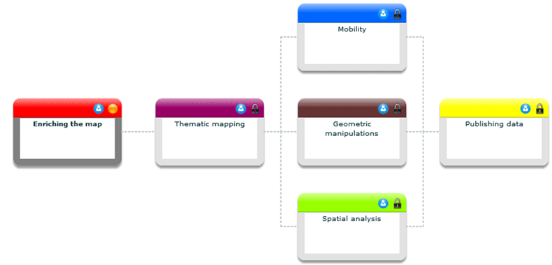
The platform accessing the different programs is very easy to use. Programs are displayed graphically: modules are color-coded and how they link together and the necessary prerequisites are clearly set out.
Within a module various sequences are on offer for completing the module. It is possible to work on different learning material simultaneously.

Finally, a tutoring component enables a student to be assigned to a dedicated tutor/trainer capable of maintaining a sustained conversation on additional technical information or concepts that have not been mastered.
Obviously, learning-related statistics are provided and tracked.


The “must-know” program


The deliverable comprises access to the 8 modules (16 asynchronous sequences) of the introductory program covering the essential features.
  • Introduction
  • Graphical manipulations
  • Tables
  • Objet selection
  • Manipulating information layers
  • Object appearances
  • Structuring data
  • Querying the DBMS

The “must-know” program


Topic program


The previous program is complemented by 5 or 6 modules upgrading one's knowledge of the classic features of data enhancement, thematic cartography, geometric manipulation, spatial analysis, mobility or data publication.
 

Geoconcept topics

  • Enriching the map
  • Thematic mapping
  • Mobility
  • Geographic manipulations
  • Spatial analysis
  • Publishing data

GeoConcept topics


Sales & Marketing topics

  • Enriching the map S&M
  • Thematic mapping S&M
  • Spatial analysis S&M
  • Mobility
  • Publishing data S&M

Sales & Marketing topics


Universal GeoCoder program


1 module comprising 6 sequences enables you to master how the different stages of the geocoding wizard work, from the presentation of the philosophy, the configuring of the data to importing them into Geoconcept, including interactive error processing.

  • Geocoding assistant
  • Geocoding assistant training program

E learning programme : Universal Geocoder


TourSolver for MapPoint program

1 module comprising 5 sequences follows a short introduction to the software philosofy. You will learn the process of the different steps to respect, how to import data, affect constraints, optimize and analyse the restults and export it.


  • TourSolver for MapPoint
  • TourSolver for MapPoint training program

E learning programme : Toursolver for MapPoint


1 day face-to-face learning (e-learning add-on)


This session enables you to consolidate the knowledge acquired during the E-Learning program and assimilate the essential methodological approaches based on a standard or customized scenario.

Contact your business engineer to obtain information on E-Learning training courses.