![]()
HERE
The essential data for any geo-marketing analysis
NOKIA is the world leader in the provision of digital mapping data and traffic and geolocated navigation data, geolocated services and mobile advertising. A special partner of NOKIA for many years, GEOCONCEPT offers a comprehensive range of data, originating from the HERE Maps range, in addition to its own software solutions.
The standard offering
The HERE Maps for Geoconcept data dedicated to geo-marketing refers to a comprehensive map range in the Geoconcept format, available for more than 200 countries. Featuring graphic design standards specially optimized for geo-marketing use, this range provides you with all the essential information for any geographical analysis:
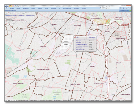
The road graph
The graph supplied with the maps is based on the road network and associated traffic speeds. It provides access to the Geoconcept GIS calculation features: catchment areas, distance table, search for the nearest, route calculations… Three profiles are available: car, truck and pedestrian.
Updating
All HERE Maps for Geoconcept data are updated annually and available by subscription. Additional updating is possible on request.
Associated data
Numerous socio-demographic data and data specific to geo-marketing analysis are available at administrative unit level. For France, 450 variables spread over 10 topics (Demography, Training, Activity, SPC, Housing units, Jobs, Family, Households, Household goods and Income) enable accurate and high-quality analyses to be performed (other countries depending on availability).
Formats
HERE Maps for Geoconcept are available in the Geoconcept format and in other GIS formats as well.
Options
Geocoding reference table
The reference table provides access to the geocoding features via the web service available directly from the Geoconcept GIS or from the Geoconcept Universal Geocoder software solution.
Specific data
For analyses providing the closest possible approximation to reality on the ground, specific data are available as an option:
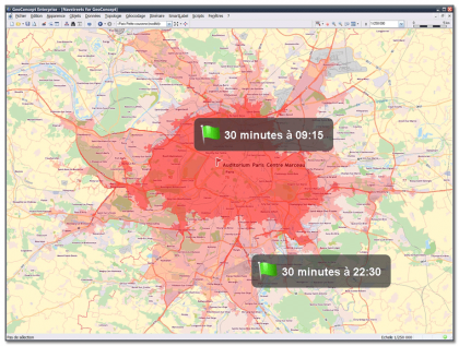
HERE Traffic Patterns TM
HERE Traffic PatternsTM is a traffic database modeled by day of week and in 15 minute slices. Available for the whole of the European network and a large number of international countries, based on GEOCONCEPT solutions, what these data enable in particular are analyses (isochrone area calculation) by hour and day of the week.
Census Area
The census areas of a territory, or division of municipalities into “units” (IRIS in France), and the associated local data (INSEE data for example) are available for numerous countries and allow more detailed analyses.
 Download HERE for Geomarketing product sheet